Picture this: hopping on an LRT from downtown London straight to Komoka Provincial Park for a weekend adventure, or catching a smooth ride from White Oaks all the way to Masonville without sitting in traffic for what feels like forever. Sounds like a dream, right? Well, one local transit enthusiast has mapped out exactly what London’s public transportation could look like if we’d started thinking big decades ago.
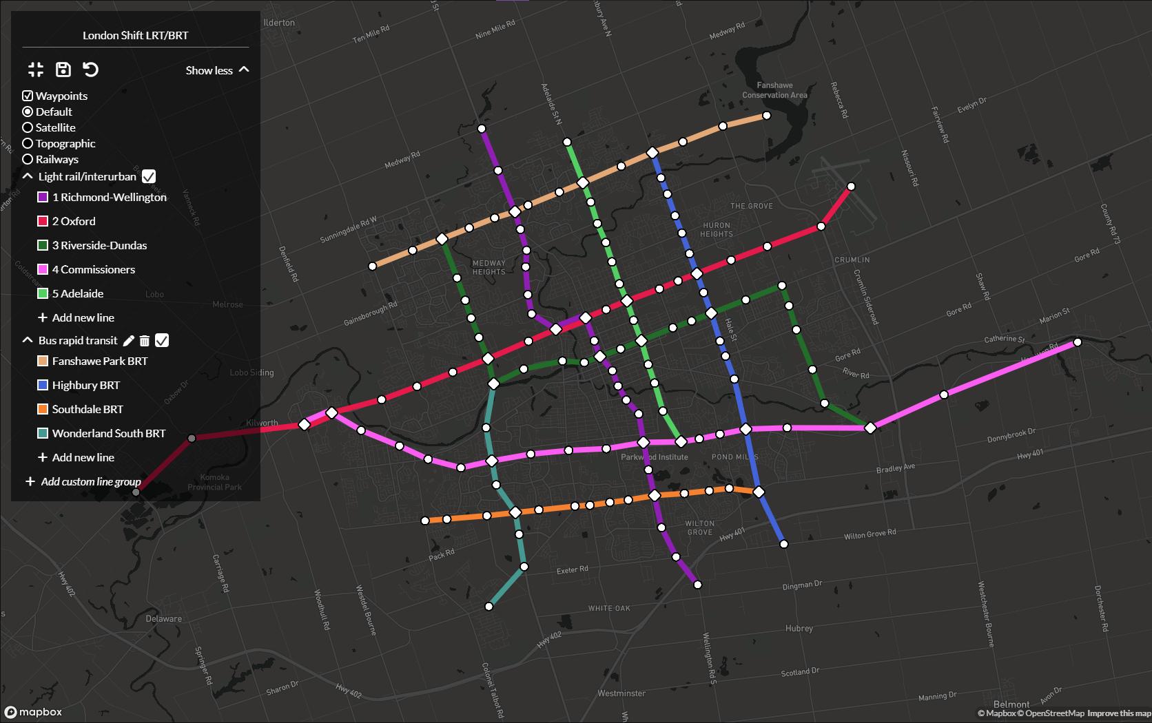
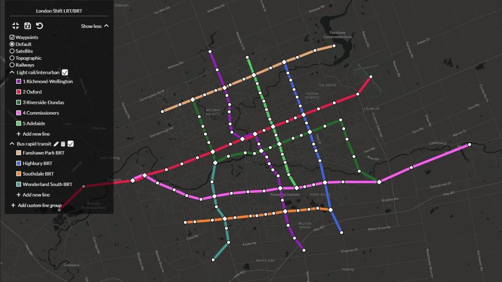
A detailed fantasy transit map making rounds in local online discussions shows an extensive network of Light Rail Transit (LRT) and Bus Rapid Transit (BRT) lines connecting virtually every corner of London and beyond. The ambitious vision includes LRT connections reaching as far as Komoka, Arva, and Dorchester, with comprehensive BRT coverage throughout the city’s major corridors.
The map features multiple LRT lines creating a web across London, including north-south routes connecting Masonville to White Oaks, and east-west lines spanning from the airport area to various destinations. The fantasy network also incorporates BRT lines along major arteries like Fanshawe Park Road, Highbury Avenue, and Southdale Road, creating what would essentially be a comprehensive rapid transit system rivalling much larger metropolitan areas.
Local residents have been particularly enthusiastic about the prospect of LRT connections to surrounding communities. The fantasy map shows lines extending to places like Komoka, which currently has extremely limited public transit options. One commenter noted the irony of needing to plan a 13-hour journey by public transit to reach Komoka, when driving takes just 20 minutes.
The conversation has reignited discussions about London’s actual transit development, with many pointing to the city’s history of missed opportunities. Former Mayor Ed Holder’s decision to decline federal infrastructure funding for transit projects remains a particular sore spot for transit advocates, with one person describing the move as turning down “$500 million in federal infrastructure funding” because “London is a car city.”
The fantasy map includes thoughtful details that show genuine consideration for London’s geography and development patterns. Lines are planned to connect major destinations like Western University, Fanshawe College, major shopping centres, and employment hubs. The network would also provide crucial connections to recreational areas, with proposed service to provincial parks and green spaces that are currently inaccessible by public transit.
Transit enthusiasts have noted that the proposed system addresses one of London’s fundamental challenges: a road network that can’t realistically be expanded to accommodate the city’s rapid growth. With London’s population continuing to surge, many argue that comprehensive public transit isn’t just a nice-to-have amenity, but a necessity for preventing the kind of gridlock that plagues other rapidly growing Ontario cities.
The fantasy includes practical considerations like connecting new suburban developments with transit infrastructure from the beginning, rather than trying to retrofit transit into car-dependent communities after they’re already built. This forward-thinking approach would integrate transit planning with water, hydro, and other essential services during initial community development.
Even the most ambitious elements of the fantasy map have sparked genuine enthusiasm among residents, with some declaring they’d support it regardless of cost. The comprehensive network would fundamentally transform how people move around London and the surrounding region, potentially reducing car dependency and improving quality of life.
While the map represents pure fantasy given current political and financial realities, it serves as a compelling vision for what comprehensive regional transit could accomplish. The detailed planning shows consideration for everything from major employment centres to recreational destinations, creating a network that would serve diverse transportation needs across the metropolitan area.
The discussion reflects broader frustrations with London’s approach to transit planning, which many residents feel has been too conservative and short-sighted. Comparisons to cities like Calgary, which built LRT when their metropolitan area was smaller than London’s current size, highlight what might have been possible with different political leadership and priorities.
The fantasy map creator has made an interactive version available online, allowing people to explore the proposed network in detail and imagine their daily commutes transformed by comprehensive rapid transit. The level of detail and thoughtful routing suggests serious consideration of how such a system might actually function in practice.
Local online discussions about the map reveal genuine hunger for better transit options, particularly among younger residents who see car dependency as both financially burdensome and environmentally problematic. The enthusiastic response suggests significant community support for ambitious transit investments, even if political will remains limited.
The conversation on Reddit has generated dozens of comments from residents sharing their own transit dreams and frustrations with the current system